By: Anurag Baruah
March 29 2023
False: Old aerial footage from Turkey has been falsely linked to a recent earthquake in New Zealand
Share Article:


Fact-Check
The Verdict False
Old aerial footage from the Turkey-Syria earthquake has been falsely linked to the earthquake that struck New Zealand in March 2023
Claim ID a3a6debf
Context
On March 16, 2023, a 7.1 magnitude earthquake struck the Kermadec Islands region in the north of New Zealand. The earthquake was estimated to have occurred at a depth of 10 km, according to the U.S. Geological Survey (USGS). Since then, possible after-shocks in the form of earthquakes of lesser magnitudes have been felt in the same region, according to reports.
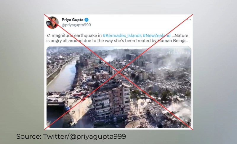
Meanwhile, multiple social media posts have surfaced online claiming to show the earthquake and its aftermath. One such video, showing what seems to be aerial footage of collapsed buildings, has been posted by various social media accounts on Twitter and Facebook, claiming to be of the recent New Zealand earthquake. The video has been posted with similar claims, among others, by a verified Twitter account with 621,700 followers and the Facebook page of a satellite news channel from Nagaland, as part of a news report. However, the video is unrelated to the New Zealand earthquake and actually shows the aftermath of the devastating series of earthquakes that have struck the Turkey-Syria region since February 6, 2023.
In Fact
We conducted a reverse image search on keyframes of the viral video and came across a report published by The Guardian on February 9, 2023, that included a longer version of the viral video. According to the report, the video shows the Hatay province of Turkey, one of the areas affected the most by the series of earthquakes that struck the Turkey-Syria region. The same video has also been uploaded to the official YouTube channel of The Guardian with the caption, "Aerial footage shows earthquake aftermath in hard-hit Turkish region of Hatay."
A 43-minute-long video comprising drone footage from Hatay in the aftermath of the earthquake was uploaded to YouTube by Reuters on February 9, 2023. At timestamp 36.40, the video shows the same place seen in the viral video, though from a different angle.
The website of GeoNet, a partnership between Toka Tū Ake EQC, GNS Science, and Land Information New Zealand (LINZ), mentions that except for the permanently manned Raoul Island Station, the Kermadec Islands region is uninhabited. Also, the Department of Conservation website of New Zealand clearly states that the Kermadec Islands is "the most remote area managed by DOC and can only be visited with a special permit."
Thus, the viral video showing destroyed high-rises in a densely populated region is evidently not from the Kermadec Islands in New Zealand, which was struck by an earthquake on March 16, 2023.
The Verdict
Old aerial footage showing the Hatay province of Turkey in the aftermath of the Turkey-Syria earthquake has been used to falsely claim that it shows the recent earthquake in the Kermadec Islands of New Zealand, which is largely uninhabited. Therefore, we have marked the claim as false.